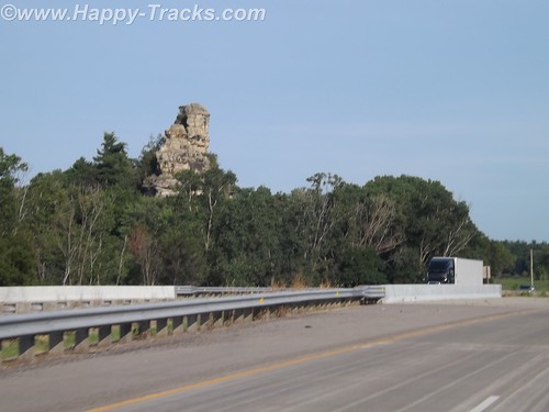
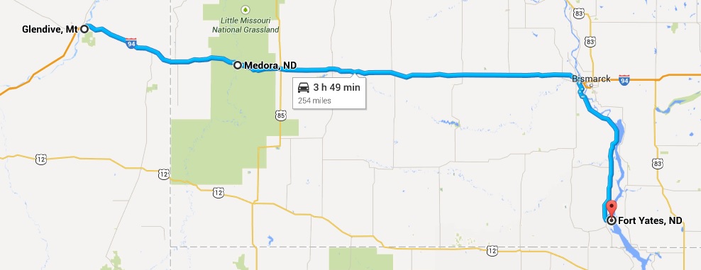
We left Medora and headed east on I-94 towards the Missouri River and Bismarck. We called a couple of hotels but found no rooms available without a reservation. Someone recommended the Prairie Knights Resort. Since it was about 50 miles off the highway, we called ahead to check on room availability. They told us they had plenty of rooms so there was no need to make a reservation. Mmmmmkay?
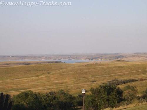
We drove south with the Missouri River to our left through a couple of very small settlements and passed the Ft. Lincoln State Park entrance. It really is 50 miles and there is virtually nothing until you reach the Prairie Knights Casino and Resort. Prairie Knights is a casino and lodge located on the Standing Rock Indian Reservation. It is operated by the Standing Rock Indian Tribe. The casino offers high stakes gaming options, along with 725 slot machines, blackjack, craps, among other games. The lodge portion of the casino consists of 200 guest rooms.
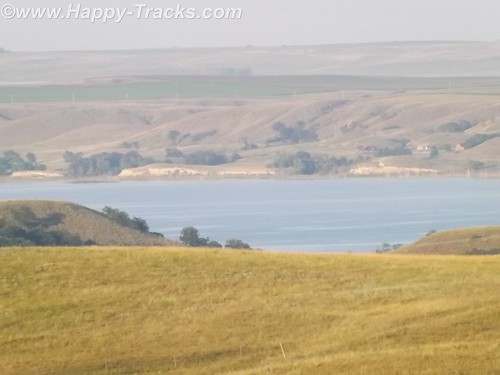
Once we finally get there, we see that they have a landing on the River, the lodge, a restaurant (buffet style), the casino and a small gas station with prices comparable to what we’d seen in Bismarck.
When we go to check in, the clerk asked if we were members of the Prairie Club. Uh, no. Before we get registered, they suggest we go into the casino and register. The registration is free but it knocks $25 off our room rate and gives us $10 to spend in the casino. We are now Prairie club members! We walk around a bit, get some dinner at the buffet and call it a night.
The next morning we head back north towards Mandan and the Ft. Lincoln State Park. Although we didn’t use them, it should be noted that the park has primitive and developed campgrounds and rental cabins near the riverbank. We didn’t go to those areas of the park to check them out. There are also hiking and biking trails.
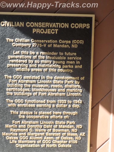
The visitor center building contains a display that includes exhibits from the Lewis and Clark expedition and from the Mandan Indians who had a village there.
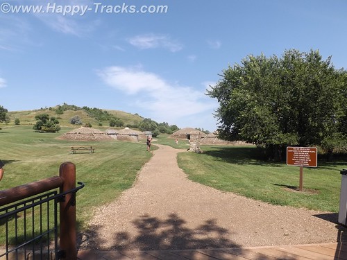
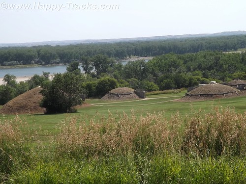
This is where the tour starts for the On-A-Slant Mandan Indian Village. Parts of the village have been the subject of archaeological research and some restoration. Their society was matriarchal with families dwelling in the same lodge including daughters and sons-in-law. The lodge would pass to the eldest daughter on the death of her mother.
The lodges were circular with a fire pit in the center, venting through a hole in the roof which could be covered in hides in times of bad weather. The lodges were also built into the earth with dirt and grass on the outside and over the roof which provided insulation from the temperature extremes. The guide told us of the lodges maintaining 60 degrees even in the coldest parts of winter and they were cool on this hot day when we visited. Generally, the lodge was entered from the side with a partition wall separating the entrance from the main room for weather and defenses. Sleeping pads were around the circumference.
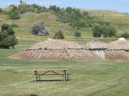
The Mandans were stationary people with language similar to the Sioux. They grew crops and hunted animals while trading with the nomadic tribes. A typical Mandan village consisted of 12 to 100 of these dome-shaped lodges. Their oral traditions indicated they had once occupied the eastern North America.
Their villages were often stockaded for protection and they hosted many of the European explorers, including the Lewis and Clark Expedition and Prussian scientist Prince Maximillian.
In 1750 there were nine large Mandan villages, but recurrent epidemics of smallpox, pertussis (whooping cough), and other diseases introduced through colonization reduced the tribe to two villages by 1800. In 1837 another smallpox epidemic left only 100 to 150 Mandan survivors. Some of these accompanied the Hidatsa to a new settlement near Fort Berthold (northwest of Bismarck) in 1845; others followed later, as did members of the Arikara tribe. The Mandan, Hidatsa, and Arikara eventually became known as the Three Affiliated Tribes (also called the MHA Nation).
In the mid-20th century, the Three Affiliated Tribes lost a considerable portion of their reservation to the waters of Lake Sakakawea, which rose behind the newly built Garrison Dam. With the flooding of the river bottoms, on which had been the best agricultural land, many tribal members shifted from agriculture to ranching or off-reservation pursuits.
In the 1870s, at the same location where the Mandan tribe had established their village, a military post was built in June 1872 by two companies of the 6th U.S. Infantry under Lt. Col. Daniel Huston, Jr., as Fort McKeen, opposite Bismarck, Dakota Territory.
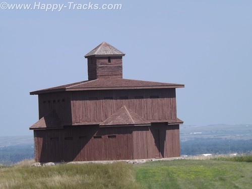
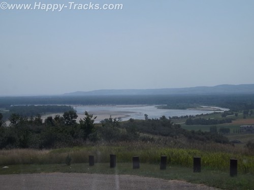
Standing today are two of the watchtowers that overlooked the juncture of the Heart and Missouri Rivers and the town of Bismarck.
The three-company infantry post’s name was changed to Fort Abraham Lincoln on November 19, 1872, and expanded to the south to include a cavalry post accommodating six companies. Among the 78 permanent wooden structures at Fort Lincoln were a post office, telegraph office, barracks for nine companies, seven officer’s quarters, six cavalry stables, a guardhouse, granary, quartermaster storehouse, bakery, hospital, laundress quarters, and log scouts’ quarters. Water was supplied to the fort by hauling it from Missouri River in wagons, while wood was supplied by contract.
By 1873, the 7th Cavalry moved into the fort to ensure the expansion of the Northern Pacific Railway. The first post commander of the expanded fort was Lieutenant Colonel George A. Custer, who held the position until his death in 1876.

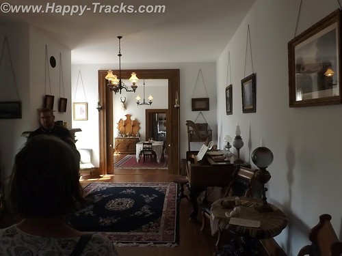
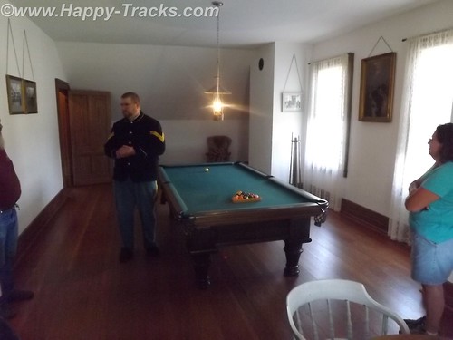
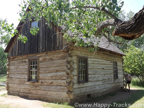
Several buildings remain at the post, including Custer’s restored (and furnished) house, the commissary (now the souvenir shop) and some stable and storage buildings.
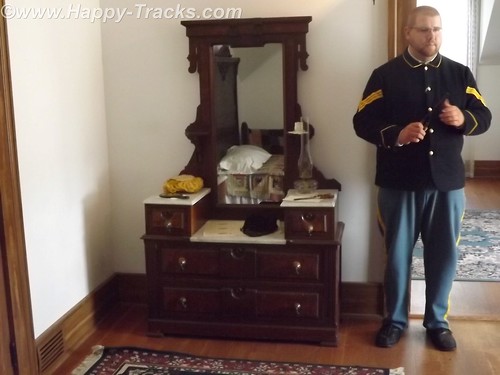
Custer’s house is open to guided tours. The tour is conducted by a man in period uniform in the role of one of Custer’s aides. The tour is alternately conducted by a woman who was in period dress. The setting is 1875 so the tour does not address the Colonel’s demise at Little Big Horn. Guests are shown through the house as arriving guests for a party to be given that evening by Colonel and “Mrs. Colonel” Custer.
The tour includes a discussion of some additions to the original house that were ordered by Col. Custer following fire damage as well as some entertainments provided to help make the rugged outpost more pleasant for Mrs. Colonel Custer.
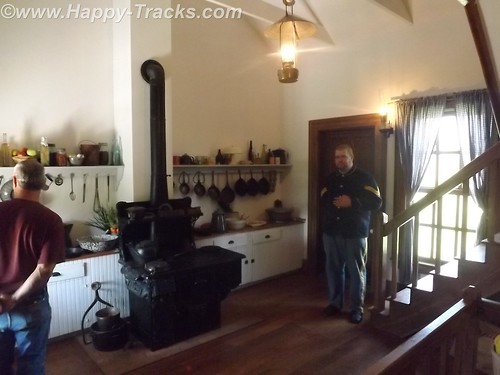
One point on the tour is the cellar where the Colonel’s pet wildcat was kept. We also toured the billiards room upstairs which served as something of an officer’s club.
As we returned from our visit to 1875, it was time to load up the truck and continue east to our next night in Fargo, ND. Our knowledge of Fargo was initially limited to the movie starring William H Macy which was somewhat gruesome. We were somewhat disappointed to find that the movie seemed to occupy a large part of the tourist industry with Woodchippers being the local drink at the bar and directions to go take pictures at the chipper in all the tourist literature. Fargo is the largest city in North Dakota at just over 113,000 people. Opposite Fargo and across the Red River of the North is Moorhead, Minnesota. The Fargo area is growing with much construction along both sides of the interstate with much of it devoted to housing, hotels and support of the petroleum industry. Some of the news stories and features of the area talk of the shortage of housing and the boom being fueled by petroleum.
After breakfast the next morning, we made tracks across Minnesota finally stopping in Hudson, Wisconsin just across Lake St. Croix from Minneapolis-St. Paul.
Hudson appears to be a small touristy town which is also a distant bedroom suburb of the twin cities. Our late lunch was in a small (but very friendly) pub style bar where we also called my nephew to see about meeting up with him as we passed near his home north of Chicago. We drove late that night, finally stopping in Loves Park, Illinois for the night.
We did connect with my nephew (whom I hadn’t seen in over 10 years) and met him for breakfast but didn’t get the opportunity to see his family due to other commitments and the short notice we had given them. Our visit was short but it was good to see him.
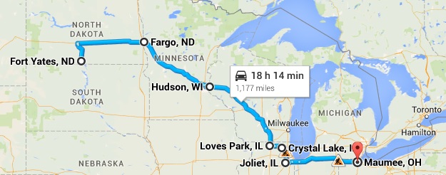
We continued on and spent the night in Maumee, Ohio.
You can see all of the pictures from this leg of the trip here.
We invite you to continue along with us and hope you enjoy the account!
Don’t forget the trip calendar we put together at CafePress. We think it turned out pretty well and would make a great holiday gift. 
Tag Archives: North Dakota
Summer 2014: Alaska via the AlCan; ND Badlands and Teddy Roosevelt NP
A young and skinny Theodore Roosevelt, Jr. made his way to the North Dakota from New York in 1883 to hunt bison. His time and experiences there shaped his perspective and the national conservation policy for decades to come. He was traveling to a place where he was an unknown and would not likely be warmly welcomed as he was an outsider, an Easterner and a “city slicker” to boot.
During his hunting trip, he expressed an interest in cattle ranching and eventually made an investment in that endeavor. In that year, the men who tended the cattle investment also built the Maltese Cross Cabin. Roosevelt’s investment of $14,000 (more than his annual salary at the time) was seen as an admission ticket to a different way of life in the wide open spaces. Dakota-grown cattle were seen as a solid investment partly because of the variety of grazing foods available and also because of the efforts of the Marquis de Morès to establish a meat packing industry to packing the meat in the Dakota territory and ship the meat in refrigerated rail cars to the markets in the east.
Roosevelt suffered double personal tragedies in February of 1884 when both his mother and his wife died the same day. The tragedy struck him hard (as to be expected) and he returned to his Dakota cabin for a period of mourning and introspection. He wrote a book about his hunting exploits and becoming a cattleman and expanded his holdings. He threw himself into his cattle raising business, becoming president of the Cattleman’s Association and stepping out to make peace with his neighbor, the Marquis, who was in jail on charges of murder. He also expanded his land holdings to include the Elkhorn Ranch.
Despite his personal warnings about overgrazing the territory, he also expanded his herds. In 1885, thieves stole his boat and he gave chase with two others eventually capturing the thieves downriver. He chose to walk the thieves back to authorities in Dickinson. The story is told in some places that he did so for the reward money or that he did so because they deserved a trial. In either event, his multiday walk to Dickinson with the perpetrators added to his reputation and helped dispel the view that he was a soft Easterner.
The seasons of 1886-1887 would prove disastrous to the cattle industry in Medora and eventually the town itself. The summer was brutally hot and dry with temperatures reaching 125F. Then after the grasses had been so devastated by the heat, the winter was equally extreme with temperatures as low as -41F. The cattle starved or froze that winter.
Although Roosevelt had been hit hard financially, he had grown tremendously in the eyes of the locals and eventually the nation. His embrace of the cowboy life contributed to his formation of the Rough Riders which brought him fame during the Spanish-American War and his experiences with the cattle contributed to his beliefs in conservation and management of our natural resources which carried into his Presidency. Although he would not return often or for long periods after 1887, the experiences shaped his actions later.
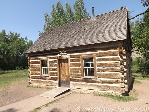
During Roosevelt’s presidency, the Maltese Cross cabin was exhibited at the World’s Fair in St. Louis, MO and at the Lewis and Clark Centennial Exposition in Portland, OR. Later it was moved to the state fairgrounds in Fargo, ND and then eventually to the state capitol grounds in Bismarck where it remained for 50 years. In 1959, the cabin was relocated to its present site and renovated. The most recent preservation work occurred in 2000.
Fellow travelers onboard the SS Matanuska, the ferry we rode along the Inland Passage recommended that we include the North Dakota Badlands as part of our journey east as they are indeed different than the South Dakota Badlands.
Theodore Roosevelt National Park is really three geographically separated areas of badlands in western North Dakota. The park covers 110 square miles of land in three sections: the North Unit, the South Unit, and the Elkhorn Ranch Unit.
We visited only the park’s larger South Unit which lies alongside Interstate 94 near Medora, North Dakota. The smaller North Unit is situated about 80 mi (130 km) north of the South Unit, on U.S. Highway 85, just south of Watford City, North Dakota. Roosevelt’s Elkhorn Ranch is located between the North and South units, approximately 20 mi (32 km) west of US 85 and Fairfield, North Dakota. The Little Missouri River flows through all three units of the park. The Maah Daah Hey Trail connects all three units.
We started our visit in Medora at the South Unit Visitor Center. Located outside the visitor center is Roosevelt’s Maltese Cross cabin. The cabin has been expanded since its original building to include an upper half story and additional rooms on the main floor.
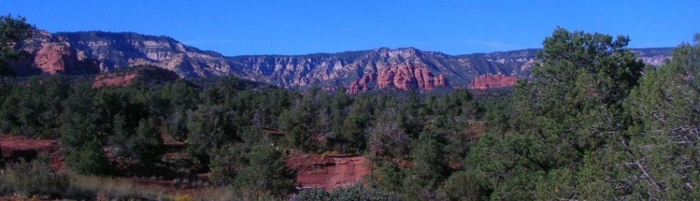
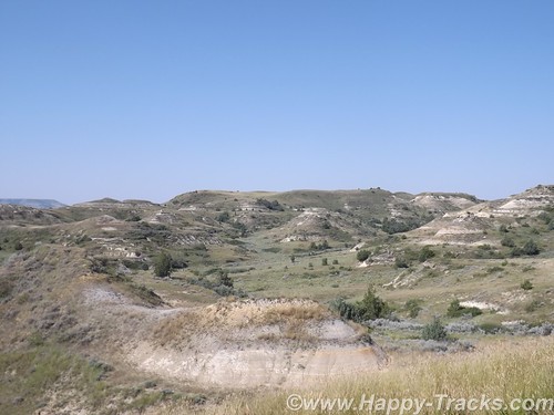
From there, we drove along East River Road alongside the Little Missouri River through the buttes. The topography of the North Dakota badlands seems almost to rise above the surrounding landscape while the South Dakota badlands seem to drop down into valleys and canyons below the surrounding landscape.
Generally the road was paved although we were stopped early on for construction ahead and the wait for a pilot car to guide us through the single lane in the dirt.

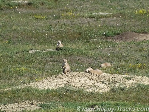
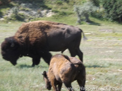
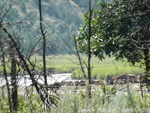
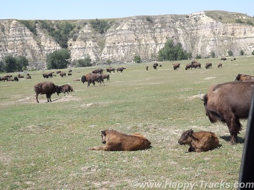
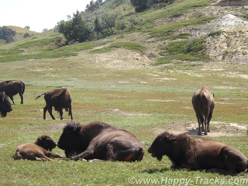
In our first stop, we were in the prairie dog area and they showed up for a few pictures. As we moved on again, we wound down to the waters edge and very soon were stopped for a view of the bison alongside the road.
As we continued on, we were stopped further along by more bison along both sides of the road and in the road itself. There were several calves in the group and the interest at this particular spot seemed to include the water alongside the left side of the road. There were probably about 6 cars stopped to wait and it seemed almost as if the bison were playing.
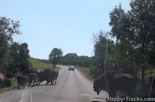
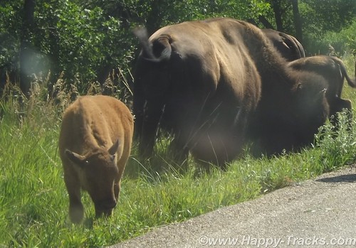
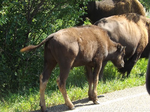
Three or four would be in the road and would finally start to move off to one side but before the first car could move, one or two more bison would come from the side. As they would move on, a couple would come from the other side of the road. Eventually, we would move on to more scenery.
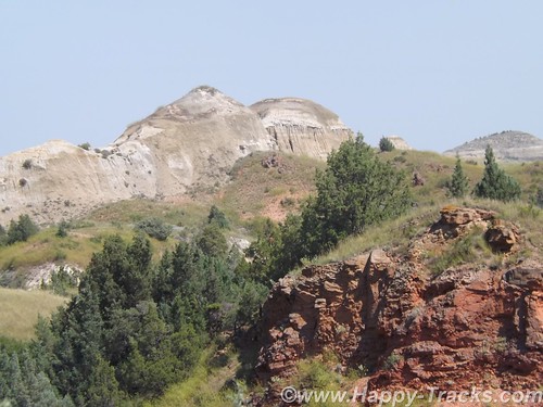
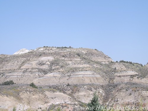
The earth showed the layers of different colors. The reds reflecting the iron content, the grays of granite-based soils, the blacks and browns of the thin layer of topsoil. There are veins of black coal. Fires in the veins of coal over the years have baked the sand and clay to a substance much like a clay brick in appearance and hardness which helps to hold the buttes and spires in place even as the lower, softer soil is eroded through the action of wind and water.
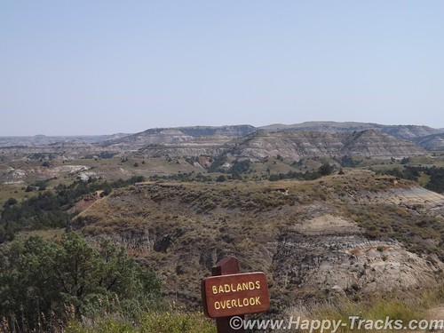
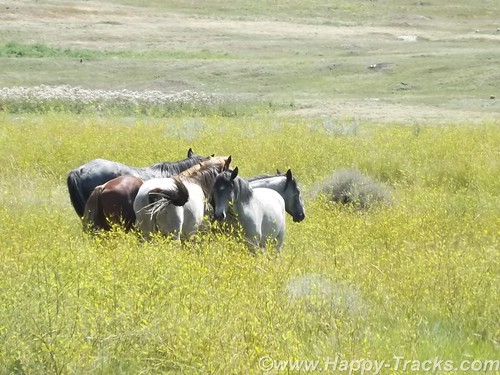
The road is a 36 miles long scenic loop which climbs and dips through all kinds of scenery as well as passing near recreation areas and hiking trails. Near one of the overlooks, we saw a quartet of horses off in a field. Chances are they were feral (of domesticated breed yet born in the wild). Towards the end, it drops again down near the river and a field where bison and prairie dogs seem to rule. The field, of several acres, included some dust wallows where the bison rolled around. You could also see that the older larger bison ruled, often causing the younger smaller ones to leave as they saw the large ones coming.
We circled on back to the visitors center where we got involved in conversation with other travelers. One was from northern Virginia and was just making their way west for this trip. Another was an old sub sailor who had served on the Nathaniel Greene and was meeting his former shipmate in the campgrounds later.
We went into Medora in search of a meal and to peruse the shops and then continue on our way to Ft. Yates for a night on the reservation.
You can see all of the pictures from this leg of the trip here.
We invite you to continue along with us and hope you enjoy the account!
Don’t forget the trip calendar we put together at CafePress. We think it turned out pretty well and would make a great holiday gift.