Summer 2014: Alaska via the AlCan, Mt. Rushmore and Crazy Horse Memorial in SD

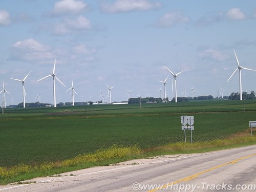
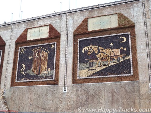
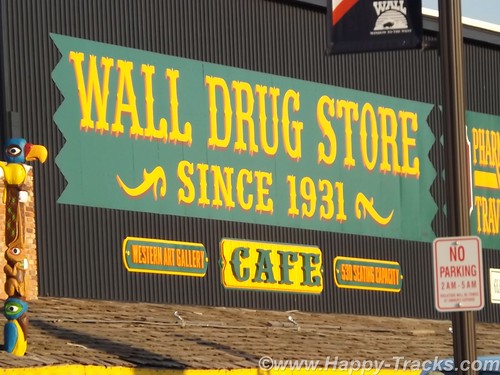
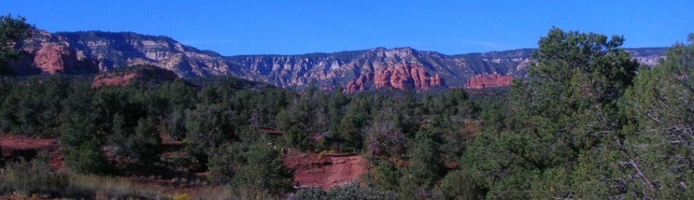
On Wednesday morning, we left Wall and made our way through the edges of the South Dakota Badlands toward Mt. Rushmore. We stayed on the interstate although the scenic loop through the Badlands was only 43 miles. We hadn’t yet fully acclimated to the amount of freedom our schedule provided. We were still able to see the Badlands though.
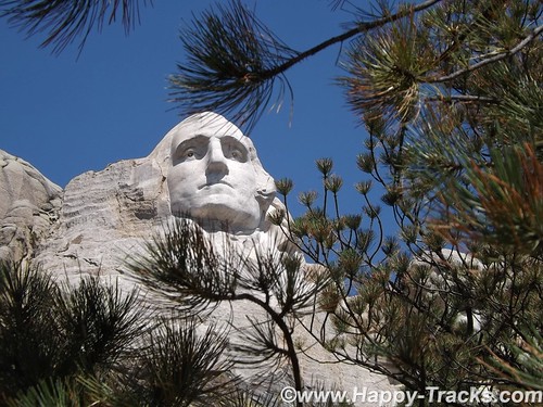
The giant granite carving of Mt. Rushmore is truly an American icon as a monument to freedom and greatness that are close to our hearts. Informally, the sculpture there has become an icon of the Great American Roadtrip Vacation which is somewhat fitting. It turns out that Mt. Rushmore shares more than geography with Wall Drug and the Corn Palace. Mt. Rushmore’s sculpture was intended to encourage tourism and get more people to visit that part of our great country. (By the way, 70 years later its still working as evidenced by our stop and the crowds that accompanied us that day. Annually, nearly 2 million people visit the monument.)
Admission to Mt. Rushmore is free but there is a charge for parking in the multi-level parking structure. Your parking fee is a one-time payment valid for the entire calendar year for that vehicle though.
When initially conceived, the sculpture included Lewis & Clark; Bill Cody and Red Cloud, a Sioux Chief representing heroes of the west. To increase its appeal, a national focus was determined to include the four Presidents we see there today. Doane Robinson, a South Dakota historian, is credited with being the initial champion of the concept.
There are varying (but similar) stories on why each was chosen
DSCF6252
Washington: Birth of a nation and the struggle for independence
Jefferson: Expansion of a nation through the Louisiana Purchase and the belief of a government by the people
DSCF6254
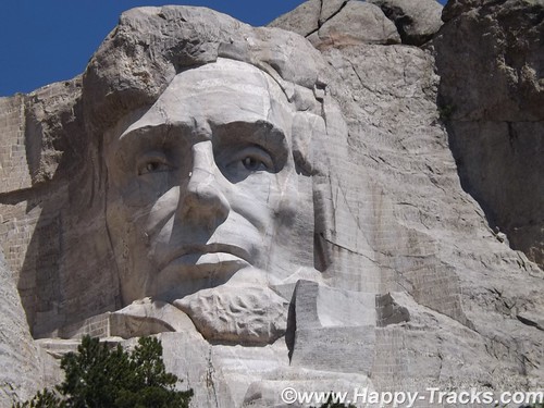
Lincoln: Preservation of the Union and Equality and Permanence
DSCF6279
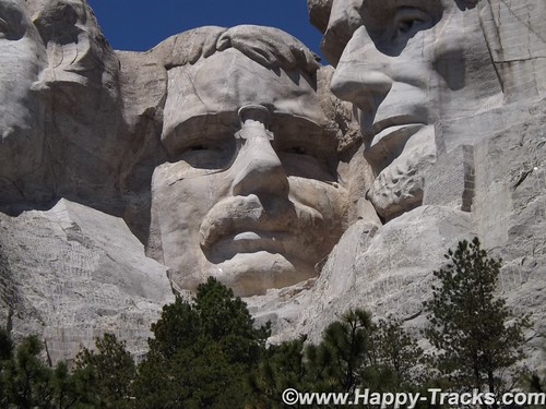
Roosevelt: Economic development of the USA, world prominence or the forward thinking of a National Parks system.
There was some thought of expanding the sculpture in 1937 to include Susan B. Anthony but the legislation precluded expansion, or scope creep. The original plans included sculpting from the waist up but construction stopped as it it is today in 1941. We also ran across at least one reference that Calvin Coolidge declared that the four chosen had to be party-balanced.
With all that background out of the way, I want to make sure to pass along that it is truly magnificent and breathtaking.
DSCF6234
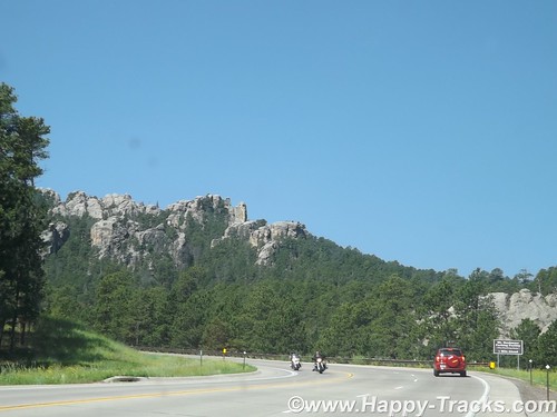
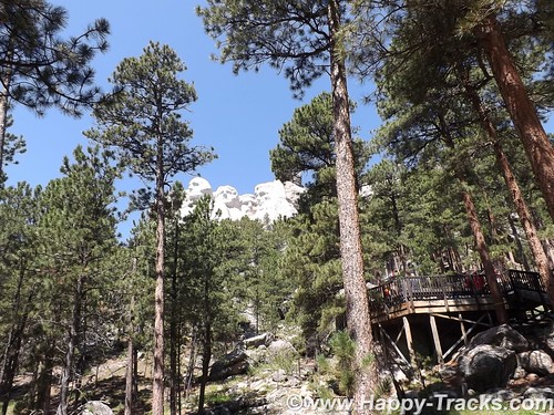
Beginning with the roadway in, the scenery is fantastic and there are ample opportunities to view the surrounding landscapes from various locations.
DSCF6240
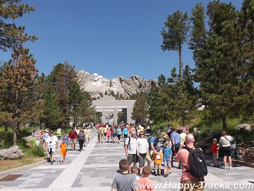
Once you’ve parked, you enter the National Monument by passing the gift shops, information booths, exhibits and eateries. Leaving there, you proceed along a majestic walkway adorned with flags from every state leading towards an amphitheater that allows you to just sit and stare or contemplate.
DSCF6259
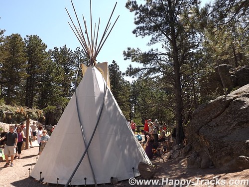
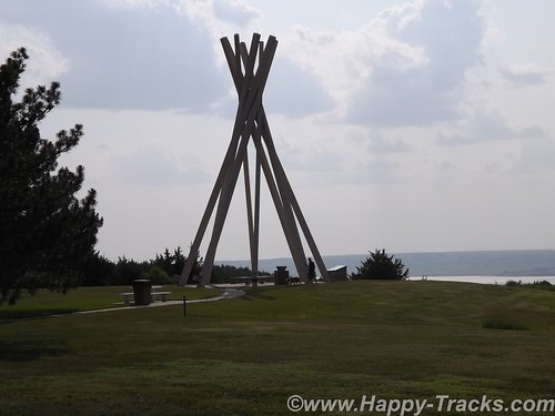
From there, you can walk along a path (handicap accessible) towards the base of the monument. Along this path, you can see a more natural surrounding and eventually reach a display that includes some teepee structures and an exhibit of a small Native American camp with music and a Ranger-provided talk.
From that point, you can look up at George Washington’s chin and proceed further along a trail in front of the base. I’m not certain of the official rating but that part of the trail, while still relatively easy walking seemed to not be accessible to some with handicaps.
DSCF6277
This part of the trail seemed to provide a spot where you could view each President individually.
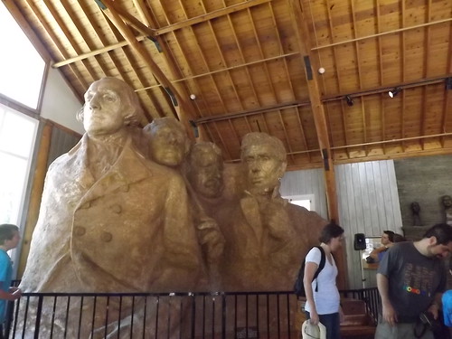
As the boardwalked trail becomes steeper, you eventually wind your way down to the artist’s studio where there are several displays including mockups of the initial sculpture. Outside there is an old generator and compressor setup that was used in the carving.
DSCF6282
Surprising to us, there is a mockup of a Hall of Records, an archival room for documents relating to the construction of the monument. While not initially included, it has eventually been built and really exists behind President Lincoln’s head.
DSCF6293
We climbed the uneven and steep (but solid) stone stairway back up to the entrance plaza were we lunched on bison burgers before checking the gift shop for postcards and continuing on our way to our next stop.
DSCF6340
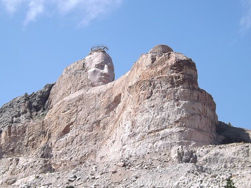
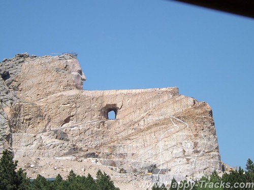
Just 16 miles away, on the other side of Harney Peak in the Black Hills National Forest is a memorial in progress, the pink-granite monument to Crazy Horse. The Crazy Horse monument is privately owned and financed and has refused government funding.
DSCF6315
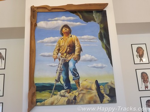
The Crazy Horse monument’s reluctant sculptor is Korczak Ziolkowski and his descendants. Ziolkowski won a prize in 1939 and was invited by Chief Henry Standing Bear to create a tribute to the North American Indians. Ziolkowski initially declined. Chief Standing Bear said, “My fellow chiefs and I would like the white man to know the red man has great heroes too.”
There was some disagreement about who the model for the sculpture should be and Crazy Horse was eventually chosen as he had a reputation for fairness and a dedication that shunned the limelight.
DSCF6333
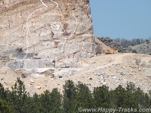
Ziolkowski had worked with Borglum on the final stages of Mt. Rushmore for a time. Conflicting stories appear as to whether he left because the work was done or because of a falling out. At any rate, in 1947, Ziolkowski had been convinced and returned to begin the work. The first blast was in June 1948. As he was working with limited funds, he was also using used equipment and with limited funding, he was often working by himself. He would tell stories of starting the compressor for the drills and beginning the long arduous ladder climb and hear the compressor chug to a halt before he had reached the top and was able to start working, necessitating the long climb down the mountain to restart the equipment and cimb back up.
According to our tour guide, Ziolkowski would work while he had funds and then would stop and do other things, including cutting timber from the property to sell. He also managed to buy up parcels of surrounding land and sometimes trade with the NPS to allow them to build contiguous parcels around Rushmore while he gathered contiguous parcels around the Crazy Horse Memorial.
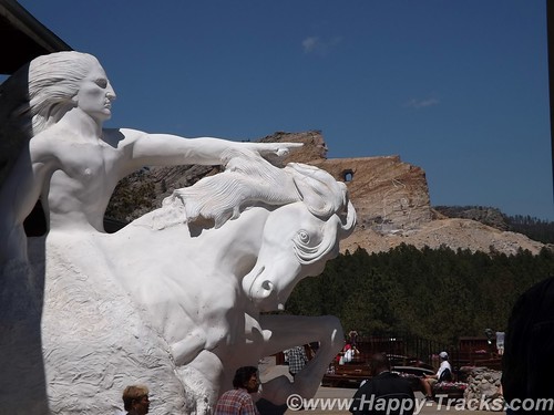
This is the largest in-progress stone sculpture in the world. By way of comparison, the four Presidents’ sculpted heads (at 60 feet each) could all fit inside the horse’s head.
DSCF6316
Mr. Ziolkowski knew the sculpture could not be completed in his lifetime but he took on the project anyway. To believe in a vision that you know you will not see completed and to sacrifice to make it happen is a strong story, especially in this day of instant gratification. He married in 1950 and they had 10 children, six of whom remain involved in the foundation and the sculpture today. He died in 1982. His wife, Ruth, ran the foundation until her death in May 2014.
When asked, Mrs. Z declined to provide an estimate of the expected cost of the monument, saying only that she expected the funds invested in the first 50 years was likely less than the cost remaining. She also expected that the timeline would still stretch for decades.
The Ziolkowski’s started a foundation which includes the museums and a scholarship fund, primarily for Native American students attending schools in South Dakota.
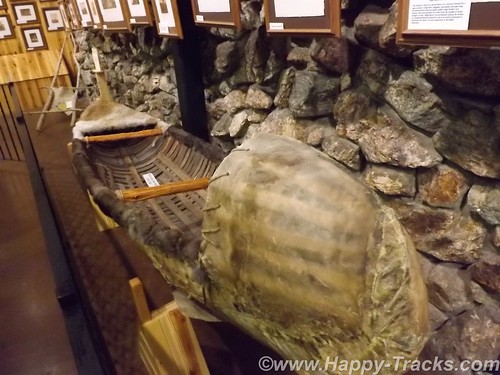
The annual visitation for the uncompleted monument is over 1 million and the grounds include a museum of Native American life as well as the sculptor’s home. Additionally, the site includes a shop where Native crafters display and sell their wares.
DSCF6330
The first definable feature, the rider’s face, 26.67 meters (87ft 6in) high, was completed in 1998, in time for the 50th anniversary of the very first blast. Work subsequently began on the next phase – the horse’s head, 66.75 meters high. Although there is still no estimated completion date, Ruth never lost her faith that her husband’s vision would eventually be realized; she said her wish was to “live more years than possible because I would love to see it finished”.
DSCF6326
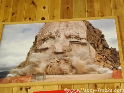
Crazy Horse, who was one of the leading figures in the Native American defeat of General Custer at the battle of Little Bighorn in 1876, pointing towards his prairie heartland. “My lands are where my dead lie buried.”
DSCF6322
We spent the night in Custer SD.
DSCF6351
You can see all of the pictures from this leg of the trip here.

We invite you to continue along with us and hope you enjoy the account!

Summer 2014: Alaska via the AlCan, Maryland to South Dakota

Sunday, July 6th had finally arrived. It was time to begin the big adventure. As it was the third day of the 4th of July holiday weekend, we had thoughts of getting an early start to avoid the leaving Washington traffic. It was probably a good idea but…we pulled out of the driveway at 11:15. It was still morning but hardly qualified as an early start. Thankfully, traffic was not particularly heavy as we headed west on I70 out of Frederick but by the time we reached Breezewood, PA (our usual entry point to the PA Turnpike), the usual weekend stop and go stretched for a couple of miles. It was a good time for lunch. When we came back out, it was apparent that the route onto the turnpike would be a grind but that traffic going west on Hwy 30 was very light. In our first “let’s see where this goes” move, we headed west on 30 and joined up with the turnpike in Bedford.
DSCF6088
DSCF6089
This part of the trip is one we’ve done several times over the years while Ryan was at college so our focus was on covering miles. We stopped the first night in Fremont IN where we discovered (quite by accident) that hotel nightly rates are sometimes negotiable. Keith hadn’t engaged the filters and said “ouch” when told what the rate was. The desk clerk asked what we had expected to pay and lowered the rate. Hmmm, might come in handy to know that later.
We did manage to get a slightly earlier start on Monday at 10:00 although we were now in Central time zone. We’re still making miles and decide to skip the RV/Motorhome Hall of Fame in Elkhart IN.
Stopping for gas, we start a conversation with a gentleman from Nokesville VA. He seemed a little surprised we knew where Nokesville was. He’s probably my age, maybe a little older. He and his wife were traveling west with his inlaws in a motorhome towing a Jeep. Their trip was to celebrate an 80th birthday for one of the inlaws. Wanderlust doesn’t give up easily, I guess.
Continuing on I90, we manage to make Chicago in time to decide that there are some places where traffic is a constant and that’s not a good thing. While there was likely a better way to get past it, we follow I90 which leads us right through the construction zones downtown. But we did see the Willis Tower (formerly Sears Tower) and the glass-floored viewing platforms (from the ground, not up close and personal).
DSCF6095
I90 takes us past Janesville, also known as the hometown of 2012 VP candidate, Rep Paul Ryan. We also pass the state capital, Madison.
North of Madison and just before I90 and I94 part ways, we pass Camp Douglas, the location for Mill Bluff State Park. During WWI, the site was chosen as a permanent training center in part because of the terrain, such as the stone pillars seen in the picture. DSCF9198During the Cuban Missile Crisis, a black bear caused the nuclear-armed bombers to scramble. You can read more about that here.
We also saw a weather front moving across rather dramatically. The rain never really materialized for us. DSCF6097
We cross the Mississippi into Minnesota and eventually arrive in Rochester MN, home of the world-renowned Mayo Clinic. We stayed in the suburbs next to the fairgrounds and had a view of the Rochester skyline.
DSCF6110
Our hotel was a shuttle stop for multiple shuttles running in to the Clinic each day. While we expected that to be somewhat depressing as folks who are visiting the Clinic are often seriously, even life-threateningly ill but the mood seemed pretty upbeat. Also, our hotel featured a bronze Viking sculpture in the lobby.
DSCF6111
DSCF6120
The fairgrounds also had a water tower sculpture of a corn cob which reminded us of the Peachoid in Gaffney SC.
An even earlier start on Tuesday morning as we continued west on I90. Farms dotted the landscape and we passed numerous power-generating windmills.
DSCF6150
DSCF6167 While it may be commonplace to those in those areas, we were surprised to see the railroad crossing style arms for blocking off the highway during blizzard conditions.
DSCF6155
Although the temperature was well into the mid 80s, the humidity was low and the continuing breeze kept things pleasant, even bordering on cool.
We crossed into South Dakota on our way to the Corn Palace in Mitchell. The Corn Palace was mentioned to us as a possible stop when I had called the Credit Card company. When she was a child, her family trip across this part of the country included a stop at the Corn Palace which she had specifically remembered from that childhood trip.
The Corn Palace is located in the center of Mitchell (right next to City Hall). Its original purpose was partly to be a tourist attraction decorated with corn cob and husk murals. It also used as an auditorium, a sports venue, the High School Prom and other civic functions.
DSCF6176
DSCF6184
DSCF6189
After a short visit to the Corn Palace (where the murals are being redone for the coming year), we were back onto I90 and headed towards the Missouri River. This crossing marked a first for both of us.
DSCF6200
South Dakota marks their rest areas with a rather unique concrete structure recognizing the teepees of the Native Americans.
DSCF6210
The landscape seems to stretch forever with a gentle roll as we get closer to the SD Badlands.
DSCF6218
We continued towards another tourist attraction, the Wall Drug complex in Wall SD. Wall Drug is and was first a drug store/pharmacy for the people of Wall SD. It was purchased in 1929 and has a become a popular tourist attraction and example of the power of marketing, initiated with giving away free ice water. See more of the history here. It is now a complex of shopping and a landmark from the early days of automotive travel.
DSCF6226
DSCF6229

After a piece of pie and 5 cents cups of coffee, we stopped in Wall for the night.
You can see all of the pictures from this leg of the trip here.

We invite you to continue along with us and hope you enjoy the account!

Summer 2014: Alaska via the AlCan Begins

In the early 50s, Mom and Dad went up and down the AlCan twice with my sisters (before I was born). In those days, mobile homes were still pretty mobile. On the second trip, they pulled their Spartan mobile home behind the Packard on the way up and behind a Chevy pickup on the way down.
Scan0067
Traveling along with them on the way to Alaska were 4 other families, also pulling their own mobile homes. The adults in those five families were lifelong friends, in part due to their shared adventures. To the best of my knowledge, two of the wives are still alive. I know my Mom stayed in touch with those folks until her death in 2007.
On that second trip, Mom had an Argus C3 that she bought with money earned from baking pies which Dad sold at work. I heard about their trip my entire life and saw the pictures and had this trip on my “bucket list” before I knew what a bucket list was. You can find quite a few of Mom’s pictures here.
On Sunday, July 6, 2014, Betty, my wife and I loaded up our Chevy Colorado and left Maryland with plans to reach Alaska and to retrace some of their route.
Much of the 1950s AlCan highway no longer exists. The AlCan was hastily constructed in 1942 as a means to reach from the contiguous United States to the Alaska territory as part of the effort to defend the territory against the Japanese in World War II and also to enable the transport of US warplanes to Russia, our allies in WWII.
Our 2014 trip included trying to re-trace part of their route and also to visit some places we’d not seen before. Our trip included time in National and state parks as well as kitschy tourist destinations along the way.
DSCF6803Our trip was taken in a Chevy Colorado crew cab pickup truck. There was no trailer but we did have a shell on the back and had taken the rear seat out to accommodate a 43 quart refrigerator/freezer that ran off of the 12 VDC accessory plug along with a spare battery. We packed a small bag with 3 or 4 outfits of shorts and t-shirts, a larger bag with several changes of warmer clotes and a loose bag with our winter coats, gloves and boots. We packed some basic foods, a camp stove, some cheese sticks and trail mix. We also had 2 spare tires, a container with an extra 5 gallons of gasoline and my toolbox and recovery equipment and a first aid kit and fire extinguisher. Electronics included our two cell phones, the truck’s OnStar setup, a laptop PC, a digital Fuji camera, a CB radio, a Ham 2M handheld, and a device called a SPOT tracker for emergency communications and routine checking in via satellite. See Find Me Spot
Along the way, we did laundry using a 5 gallon plastic bucket (originally a deli-sized container of pickle chips) with a gamma — leak resistant — sealed lid to wash clothes. We would add the dirty clothes, a little detergent and about 4 gallons of water and let it ride in the back of the truck to agitate. At night, we would take the bucket inside with us and rinse the clothes then hang them on plastic hangers from a ratchet strap strung between the two rear seat assist handles in the truck. Got a few odd looks at border crossings but it worked out well.
DSCF6352DSCF6353DSCF6842By way of preparation, we had to prepare to leave the house for 6 weeks to 2 months (our itenerary was fluid). This meant paying the routine bills (utilities, storage rental, newspaper, cellphones) in advance as we don’t use online banking or bill paying; arranging for the grass to be cut, the mail held and the newspaper delivery stopped. We also notified a few close, strategically-located neighbors of our coming absence and expected comings and goings around the house. We also attempted (unsuccessfully) to arrange for some Canadian cash through our bank and made certain our credit card company was aware we would be on the road and expecting to use the card in places and with frequency outside our normal usage patterns.
The Washington Post didn’t manage to process the vacation hold on the newspaper but our neighbor intercepted most of the unplanned deliveries. Bank of America couldn’t process our request for Canadian cash in sufficient time to get our cash before we left but a TD Bank in Alberta accepted our ATM (ABM for you Canadians) card to dispense the desired currency. One of the lamps on a timer at home decided to blow the bulb sometime (1 day? 6 weeks?) before we returned. The credit card was refused once on our trip but we think that may have been input error by the hotel rather than an issue with the CC company. Of all the logistics to be arranged, these were minor glitches that had minimal impact in the grand scheme of things.
A few statistics for your consideration.
Total driven miles: 11,704
Gasoline consumption: 556 US gallons at an average cost of $4.20 per gallon.
40 hotel nights and one on the ferry between Haines AK and Prince Rupert BC
14 states traveled and 3 Canadian provinces
1 flat tire and 1 cracked windshield
Most days, we posted up to 10 pictures on Facebook which some of you have already seen. This blog will share our story and give you a chronological account of our trip along with some more pictures and the story behind some of those pictures you’ve already seen.
We invite you to come along with us and hope you enjoy the account!